|
|
| Norway - Fjords Scoured and gouged by ancient glaciers, Norway's fjords are a veritable wonderland. These deep, sea-drowned valleys, scissored by impossibly rugged terrain, were in 2009 voted by National Geographic Traveler magazine as the world's best travel destination.
Staring gobsmacked at the imposing cliffs of Geirangerfjord.
Appreciating art nouveau architecture in charming Ålesund.
Thrilling to the delights of Bergen, a beautiful, charming city, with a World Heritage-listed neighborhood, Bryggen, and buzzing harbor, ringed by seven hills and seven fjords.
All the images in this gallery plus many many more were taken during a road/trekking trip through Norway's west coast. You can read about the trip day by day and see many more images in the Blog. Look for the posts with the title "Trekking & Road Trip in Norway"! |
|
Currently 35 panoramas in this collection
|
|
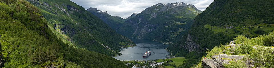
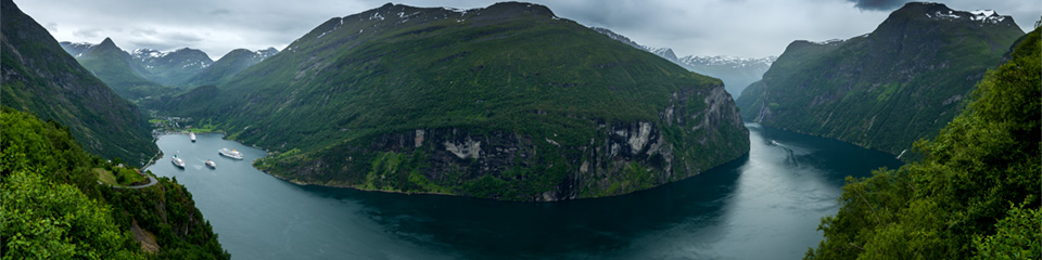
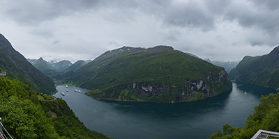
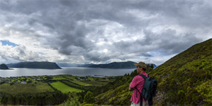
Geiranger Eagle Eye
The Geirangerfjorden is a fjord in the Sunnmøre region of Møre og Romsdal county, Norway. It located entirely in Stranda Municipality. It is a 15-kilometre (9.3 mi) long branch off of the Sunnylvsfjorden, which is a branch off of the Storfjorden (Great Fjord).
The fjord is one of Norway's most visited tourist sites. In 2005, it was listed as a UNESCO World Heritage Site, jointly with the Nærøyfjorden, although this status is now threatened by the disputed plans to build power lines across the fjord. A car ferry, which doubles as a sightseeing trip, is operated by Fjord1 Nordvestlandske. It runs lengthwise along the fjord between the small towns of Geiranger and Hellesylt.
2013-07-01
Show on map
|
Geiranger Eagle Eye
Fullscreen
|
|
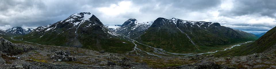
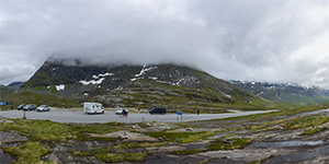
Spiterstulen
Spiterstulen lies 1,100 metres above sea level, between the two highest mountains in Norway, Galdhøpiggen and Glittertind in Jotunheimen.
Jotunheimen (English: The Home of the Giants) is a mountainous area of roughly 3,500 km² in southern Norway and is part of the long range known as the Scandinavian Mountains. The 29 highest mountains in Norway are all in Jotunheimen, including the very highest - Galdhøpiggen (2469 m).
2013-07-01
Show on map
|
Spiterstulen
Fullscreen
|
|
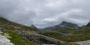
Sunnylvsfjorden
The Sunnylvsfjorden is a fjord in Stranda Municipality and Norddal Municipality in Møre og Romsdal county, Norway. The 26-kilometre (16 mi) long Sunnylvsfjorden is one of the innermost branches of the large Storfjorden. The fjord ranges from 600 to 2,000 metres (2,000 to 6,600 ft) wide and the fjord reaches 452 metres (1,483 ft) below sea level at its deepest point, just west of Skrenakken near the mouth of the fjord. The famous Geirangerfjorden branches off to the west from the Sunnylvsfjorden.
2013-07-01
Show on map
|
Sunnylvsfjorden
Fullscreen
|
|
Godoya - Alesund
Godøy is an island in Giske Municipality in Møre og Romsdal county, Norway. The island is famous for its beautiful nature, dominated by the 497-metre (1,631 ft) tall mountain Storhornet and the large lake Alnesvatnet.
There is a lot of cultivated farm land along the shores. There is ferry-free road transportation (including the Giske Bridge) that connects the island to the town of Ålesund.
2013-07-01
Show on map
|
Godoya - Alesund
Fullscreen
|
|
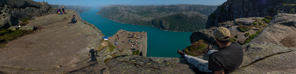
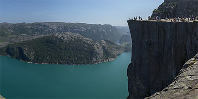
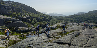
The Pulpit Rock
Preikestolen or Prekestolen, also known by the English translations of Preacher's Pulpit or Pulpit Rock, is a steep and massive cliff 604 metres (1982 feet) above Lysefjorden, opposite the Kjerag plateau, in Forsand, Ryfylke, Norway. The top of the cliff is approximately 25 by 25 metres (82 by 82 feet), almost flat, and is a famous tourist attraction in Norway.
You have to take the 3.8 km (2.4 mi) hike to get to Preikestolen. 2013-07-01
Show on map
|
The Pulpit Rock
Fullscreen
|
|
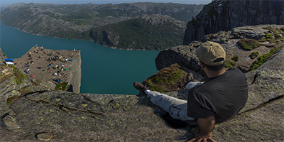
The Pulpit Rock 2
Preikestolen or Prekestolen, also known by the English translations of Preacher's Pulpit or Pulpit Rock, is a steep and massive cliff 604 metres (1982 feet) above Lysefjorden, opposite the Kjerag plateau, in Forsand, Ryfylke, Norway. The top of the cliff is approximately 25 by 25 metres (82 by 82 feet), almost flat, and is a famous tourist attraction in Norway.
You have to take the 3.8 km (2.4 mi) hike to get to Preikestolen. 2013-07-01
Show on map
|
The Pulpit Rock 2
Fullscreen
|
|
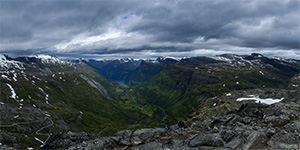
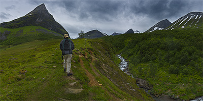
Herdals Mountain 2
2013-07-01
Show on map
|
Herdals Mountain 2
Fullscreen
|
|
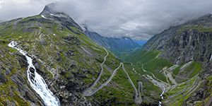
Trollstigen
Trollstigen (English: Trolls' Path) is a serpentine mountain road in Rauma Municipality, Møre og Romsdal county, Norway. It is part of Norwegian National Road 63 that connects the town of Åndalsnes in Rauma and the village of Valldal in Norddal Municipality. It is a popular tourist attraction due to its steep incline of 10% and eleven hairpin bends up a steep mountainside. During the top tourist season, about 2,500 vehicles pass daily. During the 2012 season, 161,421 vehicles traversed the route, compared to 155,230 vehicles during 2009.
2013-07-01
Show on map
|
Trollstigen
Fullscreen
|
|
Dalsnibba - Geiranger
Dalsnibba is a mountain in Stranda Municipality in Møre og Romsdal county, Norway. Dalsnibba, at a height of 1476 m (4843 ft) over sea level, offers a fantastic and breath taking view. The Geiranger fjord is seen here 1476m lower down. 2013-07-04
Show on map
|
Dalsnibba - Geiranger
Fullscreen
|
|
Storfjorden 2
Storfjorden or Storfjord is a 110-kilometre (68 mi) long fjord in the Sunnmøre region of Møre og Romsdal county, Norway. It stretches from the village of Hareid in the west to the villages of Tafjord and Geiranger in the east. The Storfjorden system branches off into several smaller fjords including the famous Geirangerfjord and Tafjorden. At the village of Stranda, the main fjord branches off into the Sunnylvsfjorden-Geirangerfjorden to the west and the Norddalsfjorden-Tafjorden to the east.
2013-07-01
Show on map
|
Storfjorden 2
Fullscreen
|
|
Lysefjorden
Lysefjord (or Lysefjorden) is a fjord located in Forsand in Ryfylke in south-western Norway. The name means light fjord, and is said to be derived from the lightly coloured granite rocks along its sides.
The fjord was carved by the action of glaciers in the ice ages and was flooded by the sea when the later glaciers retreated. Lysefjord is an extremely popular tourist attraction and day trip from nearby Stavanger, from where cruise ships travel the full distance of the fjord. As well as the extraordinary scenery of the fjord itself, two points along its length are popular side trips. The rock of Preikestolen, located above a vertical drop of 600 meters, can be seen from the fjord, but is more impressive from above. At the end of the fjord lies the Kjerag mountain, a popular hiking destination with even more spectacular drops. 2013-07-01
Show on map
|
Lysefjorden
Fullscreen
|
|
Lysefjord 2
Lysefjord (or Lysefjorden) is a fjord located in Forsand in Ryfylke in south-western Norway. The name means light fjord, and is said to be derived from the lightly coloured granite rocks along its sides. The fjord was carved by the action of glaciers in the ice ages and was flooded by the sea when the later glaciers retreated. Lysefjord is an extremely popular tourist attraction and day trip from nearby Stavanger, from where cruise ships travel the full distance of the fjord. As well as the extraordinary scenery of the fjord itself, two points along its length are popular side trips. The rock of Preikestolen, located above a vertical drop of 600 meters, can be seen from the fjord, but is more impressive from above. At the end of the fjord lies the Kjerag mountain, a popular hiking destination with even more spectacular drops. 2013-07-01
Show on map
|
Lysefjord 2
Fullscreen
|
|
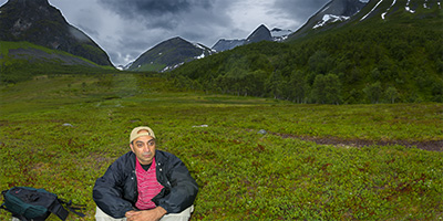
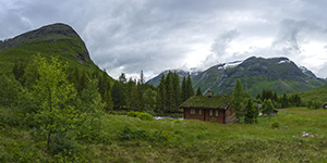
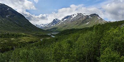
Herdals Mountain
2013-07-01
Show on map
|
Herdals Mountain
Fullscreen
|
|
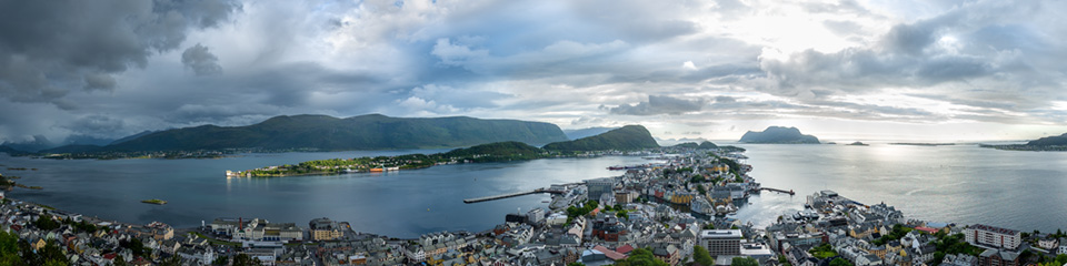
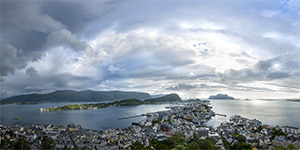
Aksla - Alesund
Alesund's viewpoint, Norway. Ålesund, a sea port on the west coast of Norway, is noted for its unique concentration of Art Nouveau architecture.
In January 1904, the town once built largely of wood, was the scene of a terrible fire. Practically the entire town was destroyed during the night and the population had to leave the town in the middle of the night. Kaiser Wilhelm of Germany had often gone on vacation to Sunnmøre. After the fire, he sent four warships with materials to build temporary shelters and barracks. After a period of planning, the town was rebuilt in stone, brick, and mortar in Jugendstil (Art Nouveau), the architectural style of the time.
2013-07-01
Show on map
|
Aksla - Alesund
Fullscreen
|
|
Gjerde Cabin Camp
2013-07-01
Show on map
|
Gjerde Cabin Camp
Fullscreen
|
|
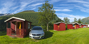
Cabin Village
A cabin village in the mountatins of Norway on Road 63
2013-07-01
Show on map
|
Cabin Village
Fullscreen
|
|
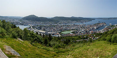
Floibergen
Fløyen or Fløyfjellet (originally written Fløien) is the most visited of the seven mountains that surround the city centre of Bergen, Norway. It has a funicular system Fløibanen that transports passengers from the centre of Bergen to a height of 320 metres in roughly 8 minutes, and the actual highest point (425 metres) on Fløifjellet is approximately 1 km to the northeast. The funicular is used by tourists and citizens alike year-round.
2013-07-01
Show on map
|
Floibergen
Fullscreen
|
|
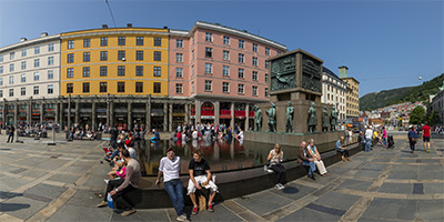
Torgallmenningen and Sjofartsmonumentet
Torgallmenningen, Torgalmenningen, or Torvallmenningen, is the main square of Bergen, Norway. Sjofartsmonumentet is a monument in the middle of a fountain in the square depicting sailing and sailors.
2013-07-01
Show on map
|
Torgallmenningen and Sjofartsmonumentet
Fullscreen
|
|
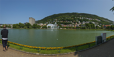
Lille Lungegardvannet
Lille Lungegardvannet is a lake south of Festplassen (The Festival Square), which is an open space in the center of Bergen.
Since 1929 Festplassen been the center of the celebration of the 17th May in Bergen, and it has also been the venue for many events such as carnival, circus and the traditional festival of lights in the city before Christmas.
2013-07-01
Show on map
|
Lille Lungegardvannet
Fullscreen
|
|
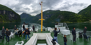
Gejranger Ferry
The Geirangerfjord is known as the real jewel of the Norwegian fjords. With high waterfalls and abandoned mountain farms, the fjord landscape is included on the UNESCO World Heritage list. Here you find unspoilt and beautiful nature.
Ferry cruises take you on a journey through the area's dramatic scenery. Very steep mountains and wild waterfalls. Among the Geirangerfjord's nine most famous waterfalls are the Seven Sisters and the Bridal Veil.
2013-07-01
Show on map
|
Gejranger Ferry
Fullscreen
|
|
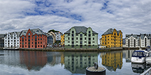
Alesund
Ålesund, a sea port on the west coast of Norway, is noted for its unique concentration of Art Nouveau architecture.
In January 1904, the town once built largely of wood, was the scene of a terrible fire. Practically the entire town was destroyed during the night and the population had to leave the town in the middle of the night. Kaiser Wilhelm of Germany had often gone on vacation to Sunnmøre. After the fire, he sent four warships with materials to build temporary shelters and barracks. After a period of planning, the town was rebuilt in stone, brick, and mortar in Jugendstil (Art Nouveau), the architectural style of the time.
2013-07-01
Show on map
|
Alesund
Fullscreen
|
|
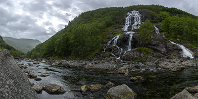
Brattland
One of many stunning and refreshing waterfalls you can find along the ways in western Norway if you keep away from motorways / freeways. This one by Riksveg 13 on my way from Preikestolen outside Stavanger towards Oslo. 2013-07-01
Show on map
|
Brattland
Fullscreen
|
|
Mountain Road
2013-07-01
Show on map
|
Mountain Road
Fullscreen
|
|
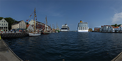
Stavanger
Stavanger is the third-largest urban zone and metropolitan area in Norway, located on the Stavanger Peninsula in Southwest Norway. Stavanger's core is to a large degree 18th and 19th century wooden houses.
Especially in the summertime the harbour is full of large cruiseships. The Port of Stavanger is a popular stop on the route to the Norwegian Fjords. Lysefjorden is popular for hiking. Tourists typically visit places like Preikestolen (aka the Pulpit Rock), and Kjeragbolten.
2013-07-01
Show on map
|
Stavanger
Fullscreen
|
|
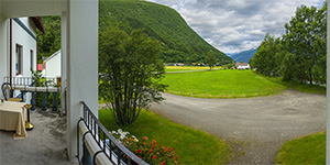
Petrines Gjestgiveri Hotel
2013-07-01
Show on map
|
Petrines Gjestgiveri Hotel
Fullscreen
|
|
Riksvej 55 to Bergen
2013-07-01
Show on map
|
Riksvej 55 to Bergen
Fullscreen
|
|
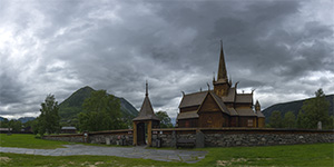
Lom
Lom, Gudbrandsdal is a municipality in Oppland county. Seven of Norway's ten highest mountains located in Lom, including the highest, Galdhøpiggen.
Highway 15 runs through the municipality and county road 55 over Sognefjellet starting at Fossbergom.
The highest peaks in Norway, Galdhøpiggen and glitterati are in Lom and more than half of Jotunheimen National Park is located in Lom.
2013-07-01
Show on map
|
Lom
Fullscreen
|
|
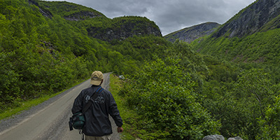
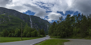
Road to Trollstigen
The road to Trollstigen viewpoint
2013-07-01
Show on map
|
Road to Trollstigen
Fullscreen
|
|
Road 63 - towards Trollstigen
Road 63 - towards Trollstigen
2013-07-01
Show on map
|
Road 63 - towards Trollstigen
Fullscreen
|
|
Sigernessjoen
Sigernessjøen is a lake of 2 km² in Kongsvinger in Hedmark, ca. 8 km south of the city center along Highway 2 towards Eidskog municipality.
The lake is a popular swimming spot, and there are two campgrounds close by.
2013-07-01
Show on map
|
Sigernessjoen
Fullscreen
|
|
Biristrand camping
Biristrand camping in Norway.
2013-07-01
Show on map
|
Biristrand camping
Fullscreen
|
|
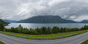
Storfjorden
Storfjorden or Storfjord is a 110-kilometre (68 mi) long fjord in the Sunnmøre region of Møre og Romsdal county, Norway. It stretches from the village of Hareid in the west to the villages of Tafjord and Geiranger in the east. The Storfjorden system branches off into several smaller fjords including the famous Geirangerfjord and Tafjorden. At the village of Stranda, the main fjord branches off into the Sunnylvsfjorden-Geirangerfjorden to the west and the Norddalsfjorden-Tafjorden to the east.
2013-07-01
Show on map
|
Storfjorden
Fullscreen
|
|
Road E136
Road E136
2013-07-01
Show on map
|
Road E136
Fullscreen
|
|
On the Road to Alesund
Road to Alesund, Norway.
2013-07-01
Show on map
|
On the Road to Alesund
Fullscreen
|
|
Lillehammervegen
Lillehammervegen road in Norway.
2013-07-01
Show on map
|
Lillehammervegen
Fullscreen
|